Trekking and making journey as a hobby just happens to you, you
never try hard to chase it. I had covered all the major trekking trails near
Bangalore in my 4 years stay here. But the Kumar Parvatha trail was long due.
 |
| At Summit. |
Kumara Parvatha also called a Pushpagiri, is one of exciting
trek locations in Karnataka. Popular among trekking fans as KP, the Kumara
Parvatha trail is well trodden but equally challenging. Typically takes over
night stay on the mountains to finish the trail, if you start trail from
Somawarpet side you could able to finish the trail end of the day unlike other
side from Kukke. The trek route is fairly in an East - West Orientation across
the Western Ghats. In other words you will be trekking across the Western
Ghats, scaling the third highest peak in Karnataka.
 |
| Sri Shantha Mallikarjuna Temple, Heggademane Village. |
The eastern end of the trek is a Beedahalli, a remote village,
some 22 km from Somwarpet town in Coorg. The western end is practically the car
street of temple town Kukke Subramanya temple. For those of you who haven’t
heard about this quiet lesser known place Pushpagiri Wildlife Sanctuary which
has Kumara Parvatha and temple town Kukke Subramanya, Subramanya is famous for
the Kukke Subramanya temple.
Embraced by the Kumardhara River, this town worships
the snake god. Apart from the temples, for the people who are interested in
wilderness and drives, this proves to be a perfect place. There are many dirt
tracks leading to small villages and mountains near by situated deep inside,
but it is advisable to take those routes in winters and early in the summer as
trail during monsoon makes more challenging. The place has such a thick
tropical forest that if by any chance you lose way, there is no chance that
you’ll be able to come out of the jungle on your own.
 |
| Just started the trail. |
Between these two points Beedahalli and Kukke lies a varying
stretches of terrains with, equally varying difficulty to trek. Approximately
at the midway point is the Kumara Parvatha peak, hovering over 5,600 feet above
sea level.
So here come the first decision you would need to make, if to
trek from Subramanya side or from Beedehalli side. And still, if you would want
to trek the full trail or trek up to the Kumara Parvatha peak and return back
to your starting point, be it Subrahmaniya or Beedehalli.Whatever is the
decision, it's about 20km of trek overall.The biggest highlights of Kukke Subrahmaniya end are its better
connectivity and the relatively better facilities around the town (hotels,
shops, restaurants etc). And of course
the Kukke Subrahmaniya Temple itself.
How does it fare on the Beedehalli side? This tiny village is
sparsely connected with Somwarpet by the lone bus service. This is about a 22km
journey. You need to get to Somwarpet for any long distance connections, like
to to Bangalore (240km, 5hours) or Madikeri (40km, 1½ hours). There are about 6
direct bus services between Somwarpet or Bangalore. And quite a few to Madikeri
with Somwarpet.If that lone bus service to/from Beedehalli does not gel well
with your itinerary, consider hiring a local jeep service to Somwarpet, a
popular means of transport in this part of the state.
 |
| Hangover Bridge near APC. |
In summery, the Kukke side fares a bit well from the
connectivity stand point. What about the trek itself? Which direction is more
favorable? From Kukke or Beedehalli? For a couple of reasons the Beedehalli
side is a shade batter to set off the trek. To understand this take a look at
the topography and the nature of the trek path.The 14km trail from Kukke to Kumara Parvatha peak is all about
scaling 1½km (about 1500 m/4930 feet) in elevation. From the Beedehalli you'll
reach the Kumara Parvatha peak after 600 meters of elevation over a 7km long
trek. That's Beedehalli is already at an elevation of 1100 meters, where as
Kukke is about 140 meters.So from a difficulty scale the Beedehalli to Kumara Parvatha
peak fares better or less challenging, if you're an avid climber.
 |
| Except me. |
With all these pros and cons we had chosen Beedahalli APC to
start the trek. This side of KP less known to the trekking fraternity of Bangalore
which poses an equal amount of challenge along with comforts when compared with
Kukke side.This is a trek for all of us who have been wanting to be on top of
Kumara Parvatha for a long time. One of the major attractions about path from
Beedahalli side is the dense forest cover more or less throughout the peak. The
dense cover trail is around 7 kms from the start, last one kilo meter is less
covered with forests and has some huge volcanic rock formations one has to
climb.
 |
| Don't ask what I was thinking of!! |
To begin with, this trek was planned one month back. Although I
wanted to make this trek happen, it was difficult to get people to confirm and
also arrange for a tent and sleeping bags.I spoke to Yathiraj a freelance Well-known travel
guide(Organised our Brahmagiri trek) who works closely with KMA and YHAI. We
confirmed our interest with Raj and we went to get a sore foot.I was longing to
go to this place ever since, so decided to trek the hill Kumara Parvatha as I
committed , early in the winter with my colleagues Nagesh, Pramod, Hemanth,
Thilak, Guru, Yuvraj, Prakash, Sagar, Sanjay, Sandesh and my cousin Deekshith.
 |
| Posing like ..! |
Reached Shanta Mallikarjuna temple at Heggademane village after
over night journey by 5:30 in the morning. After a break of about 2 hours which
included freshen up near the temple, finishing morning daily routines and also
having breakfast.This was at 8:00 am, Started off towards the hills. The road
became thinned, people density reduced to zero and finally we found a small
camp Bedahalli APC. Yathiraj managed to get permission to get into the forest
from the forest department, Madikeri range.
 |
| Near Second stream. |
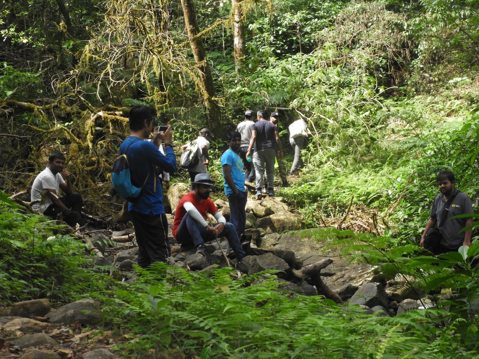
We left all our extra baggage,tents we carried at APC and
started the climbing.Now the actual trekking starts into the thick forest, our
plan to come back to the APC to stay in the tents we had for the night and try
to visit the beauteous Mookanamane water falls.We had come well stocked as far as food was concerned, Carried
almost 70 rotis and Chutney Powder, lot of Curd and Vegetable Salad for
munching.We stopped for water at a couple of small streams flowing down
across.The tree cover cast a pale green shadow over everything and the
recent rains had put that cool, semi wet tropical touch on the trail. Walking
along it, it was easy to ignore the leeches pushing for space in my shoes and
simply get lost in the wilderness around me.
 |
| Leechy Deekshith. |
While climbing up the rock face which was pretty easy by the
way, since it was mostly dry and my shoes gave me good grip on them, I was
wondering how it would be like in the rains.I could see water channels all over
them and thought about how cool it would be to climb it in the rains! After that, the gradient continued to be high. Every one
starting to feel tired and had to take a couple of breaks in between.The
initial part of the trail was very easy and I soon got ahead of the others as I
was walking at a pretty brisk pace. Soon, we came to a pretty steep(about
50 to 60 degree I guess) rock face and from then on the climb was pretty
tough.This stretch is more like a rock climbing experience as there is a
monolithic stone formation which you have to cross.
 |
| Diversion sign board to Peak and Girigadde. |
 |
| Monkey Skills. |
 |
| Small rock patch. |
Finally, by about 1’o clock we broke out of the tree cover and
to the stretch of rock just below the peak. From here you could able to reach
the top of KP just in matter of time.The weather atop the peak had absolutely no relation to the
conditions below it. It was little hazy and clear continually following, by the
time we reach peak we were all very hungry. To add more amusement for sometime
Thilak, Pramod, Yuvraj became just like African hunger victims literally
attacking me to take away and pulling the vegetables while I am preparing the
vegetable salad. Took out the food we had Chapathi and Chutney powder we had,
finished it just in matter of time. Once we done with our lunch Photography as
usual started off with a bang. All of us clicking pictures, admiring the beauty
of Pushpagiri Wildlife Sanctuary.
 |
| Just after first rock patch. |
 |
| Pammi n Hemu. |
We were out of the peak and into the ridge adjacent to the peak
lush green grass land was visible all around you up to at least 30 kms.The
sight was just an elevated feeling of how wonderful nature is. You could see
two peaks other from the peak namely Shesha Parvatha and actual Kumara Parvatha
hill(We were on Pushpagiri Hill by now).Around 2:30 we started back, the descent was little steep as
conquered, unfortunately Sagar suffered with muscular contraction while getting
down. No matter what he took his time and got down in company with us which
made a very good time throughout. A dog accompanied us on our way down for me
and Sanjay all along.
 |
| Second rock patch. |
 |
| Sesha Parvatha. |
By 6’o clock everybody was there at APC, we split into random
groups while descending down had an opportunity to explore the stunning scenery
of Pushpagiri forest. Even though we were tired we maintained our grit and
tenacity.It became dark, temperature fallen down to 15c at the time which
made bit uneasy. It took about two hours to prepare dinner comprised of Rasam,
Rice, Pickle, Papad and Butter milk. It is normal in routine life but being
trekked whole day made us tired enough, since everyone hungry it became
sumptuous meal for us.
 |
| He He..., |
 |
| Prakash and Yuvi. |
When everybody was ready to sleep, Pramod started his relentless
chat session with Yuvraj and Hemanth. They were discussing about ranging from
least to most happening things in boys life and made sure that nobody got a
good sleep. I was snoring all night(Thilak and Deekshith was prey for this
whole night)... but I am damn sure that I didn't!! That morning when we woke up the temperature would have been
somewhere around 10 degree Celcius or so and we were shivering. Myself and
Yathiraj prepared poha for Breakfast meanwhile everyone got freshen up at near
by stream flowing down to the valley. Soon finished our Breakfast, with full
tummies our day of exploration continued from Beedahalli APC bidding adieu to
forest staff.
 |
| Early in the morning. |
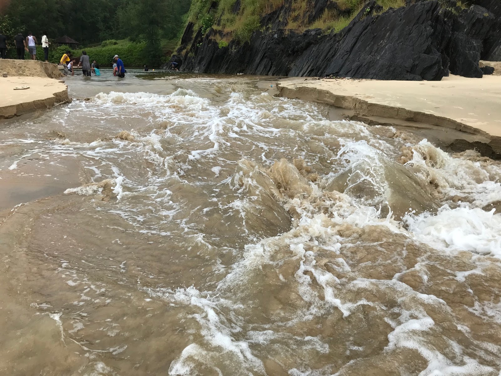
It is around 30 kms from Beedahalli to reach Mookanamane falls.
On a brighter day we got to drive around some lonely roads with lovely
views.The Mookanamane falls is located 35 km from Taluk headquarters
Sakaleshpura, 12 km from Vanagur and hardly 3 km from Attihalli village.By the time we reach Mookanamane falls it was around 11:30. To
reach the waterfalls one has to follow the Jeep track by parking the vehicles
half a kilometer from the falls. Small vehicles like cars could go further down
almost near to falls upstream. A small and wider Nagarahole stream flows down
all the way from Bisle Ghat range of hills. The mesmerizing waterfalls located
amid the forest makes it almost a private waterfall due to less holidaymakers.
The water falls from around 10 to 15 feet height and spread across about 20
mts.
 |
| Mookamana Abbey Falls. |
It was adventurous walk along the upstream to reach down the
falls. The rocks are very slippery and one should be very cautious when they do
adventures on the rocks. We managed to reach down the falls with Trees, roots
and rocks to our rescue.Few sat on the wet rocks, remaining had nice shower
under the huge falls. We thoroughly enjoyed the glory of Mookanamane waterfalls
and beauty of nature at its best.I was busy planning and dreaming about my next trek(trip)
meanwhile everyone enjoying the movie our way back. Overall the visit to this
place is worth and if you are planning to go there, you will get to see some of
the virgin beauty. Pushpagiri and Bisle reserve forest are the perfect choice
for a attraction that lets you experience the mesmerizing quality of being
pleasant.
 |
| Bidding Adieu to APC. |