StatCounter

Monday 19 February 2018

Getting lost in Sandhan Valley; Maharashtra's Very Own Grand Canyon.

Continuous from Kalsubai trek. 

Exploring the Sandhan Valley (The Grand Canyon of Maharashtra) along with visit to Bhandardara dam was our plan as soon as we are done with Kalsubai trek. Ratangad fort (The Jewel of Sahyadri) falls in the same range of peaks, which offer the finest views in the Sahyadri. For those unaware of this place, Sandhan Valley is a 200 feet deep canyon situated in Western Ghats of Maharashtra. Closer to the beautiful Bhandardara region, the valley is surrounded by forts like Ratangad, Ajoba and the famous troika of Alang-Madan-Kulang (AMK) forts. Kalsubai, the highest peak in Maharashtra (1,646 m) is also close by.

@Team
Our journey began at 1:00 PM from Bari Village; from there we took a shared jeep to Shendi (Bhandardara Base Village) which costs us Rs 20 per head, reached Shendi at around 2.00 PM. From Shendi to Samrad which is base village for Sandhan Valley, there is no proper mode of transport, be ready to spend ample of time at Shendi. Meantime we had visited the Bhandardara Dam, which offers some spectacular views of Sahyadri’s and Ratangad fort view too. 
Bhandardara Dam view.


Sandhan Valley located 25 km from Bhandardara, behind Samrad village, is located in the Ahmednagar District of Maharashtra in the Akole taluka. The road between Shendi and Samrad offers the best views of the surrounding peaks like Ghanchakker, Kalsubai, Ratangad and the AMK mountains. You can also view the Bhandardara dam and umbrella waterfall when the gates are opened. Bhandardara dam is one of the oldest reservoirs in India built in 1910 across River Pravara. There is also reversing water falls nearby but it's active during monsoon only. We waited for the jeep longtime, and finally began our journey to Samrad, reached Samrad village at 6 in the evening. This was the time where I could see the Sun whacking through the mountains and there were different shades of colors spread all over the sky.
Backwaters of Dam near Samrad village.
Sandhan Valley is known by many names Grand Canyon of Maharashtra, Valley of Suspense and Valley of Shadows. Conversely, Sandhan is no comparison to the Grand Canyon of USA which is a 445 Kms long canyon cut by the Colorado River, Sandhan is barely 2 Kms long. Sunrays reach the valley only for a short span of time during the day when the sun is directly above the canyon, thus the gorge remains in shadow for most part of the day. There is no suspense in the gorge or the valley beneath. Sandhan Valley is a wonder of natural surroundings with stunning views, chilly weather and the spellbound majesty of nature.
Mr. Nags 
Being a remote village there are no hotels in Samrad. The locals make home stay arrangements. Trekkers and Mountaineers can opt to stay in their own camping tents carried along. There are no shops in Samrad, hence it is suggested to carry refreshments, packaged drinking water and medicines. Clean drinking water is also available from nearby well. There are no toilets in Samrad hence one has to make own sanitation arrangements in the open jungle. Stay put in the lap of nature in a camping tent is a thrilling experience and undoubtedly the best stay option. For more convenient and warm accommodation opt for homestay. Home cooked local Maharashtrian food is available consisting of Bhakri, Bhaji, Dal, Usal, Rice, Thecha and pickle. Breakfast could be Poha, Upma or Maggi with piping hot tea all cooked.
Initial patch of Valley.


Crossing 1st water pool.
On our way to Samrad we met a person who owns a Home stay near Samrad close to Dam backwaters. He offered us rooms to stay as a part of his home stay promotion for freely and also helped us with food, arranging guide. He was really helpful, charged a little amount only for food we had there. Our initial plan was to reach KonkanKada on the same day, as it was getting late and long lasting Kalsubai trek we decided not to visit. In the course of our conversations with the Home stay owner on the previous day, it was decided that we would start by 6 am from there next morning. He had shared his experiences of Sandhan Valley; how it came to existence and how Samrad village men and youth are getting benefited out of it. 

Rock confounded rainwater sliced valley!!

2nd Pool.


Steep valley and deep narrow route under over hangs in the mountainsides.


Samrad village people used to catch the fishes for their daily needs at Sandhan Valley before it became famous. Few years back, a researcher from Mumbai came in search of Nature’s glory here at beautiful valley of Shadows, published an article in local news paper at that time Valley of Shadows got more promotional. He also said “The youngsters of our village are using this Sandhan Valley like a ATM Machine by charging some decent amount for rappelling, bouldering & camping from the enthusiastic trekkers & groups”.
Nothing to help you, but your hands & your own head. 


Sandhan Valley is a gorge cut by wild water streams gushing down ferociously from nearby mountains during the monsoons for past thousands of years. The streams fall in to the valley beyond the gorge and form a pond. To reach the pond one has to rappel down from the far end of the gorge in to the valley. The views from the far end of the gorge are truly breath taking and the experience is amazing.


We started off from home stay early in the morning towards Samrad and there we met our guides Machendra and Atul Mandi, who were waiting for us. The initial part of the hike takes you through forest. Around 7’o clock we reach starting point of Sandhan Valley. Soon you enter the valley there is a rock patch close to 1st water pool which is quite easy one to descend down. During November and December months at the 1st water pool water would be around 2 to 3 feet, being it in January water receded to 1 ft.
  
Big rocks patches crossing were challenging job.

Almost near 1st rappelling point.

At the right hand side there is narrow route along the rock gorge, by taking support of rock using both hands, we balance our body and walked on narrow route until we cross the pool. Further down there is second water pool where the water level was around 4-5 ft. After crossing many boulders we reached 2nd pool, we all carried trekking sacks on our head and managed to cross towards other side of pool. Once you cross the 2nd water pool we would be half way through the Sandhan valley. Depth of valley was really scary to see from the top of the mountain. It was impossible for light to reach in the depth of valley. 

Tough & Challenging crossing huge boulders.

One can descend the valley beneath the far end of the gorge through rappelling. There are three big rock stretches, one 40 feet high, while the other two relatively smaller at 15 feet and 10 feet. By 9’o clock we reached 1
st rappelling point which is huge having 40ft deep. Tirth started with the proceedings rappelling down, and then we followed him while others giving courage to move ahead without fear. The trek itself is just about 2 Kms and is a complete decent, but it's full of boulders and two ponds which are full water just about waist high. If you want some rough adventure over the weekend then this place has to be on your list. Mind you this place is not fruitful for beginners; this needs some serious trekking and requires a lot of energy and skill to cross the valley.
Getting ready for adventure.

1st Rappelling point.

Tirth taking initiative rappelling down. 


Sandhan valley kept us amazed till the end. It's a nice place to visit and a place that is unique. Making way through the rocks is a new experience one can think of. However taking care while walking through this valley is utmost vital. Food is available at nearby village, but has to be kept informed prior for preparation. Sufficient water has to be carried. Keep yourself prepared for the long ride as it’s located quite away from the main road. Enjoy every bit of it. Sandhan is a great place to test a trekking endurance - it provides a challenging yet a beautiful trekking path to remember - simply awesome. Sun-rays obstructed by high rocks on both the sides of valley emit beautiful shadows in valley and echoes from footsteps. A full venture of adventure and beauty I would say - Rock climbing, bouldering , Shadows , Waterfalls , Ponds , reptiles , bats and a lot more to see. Best thing is it is not crowded like any other trek place - even clean compared to other trekking places and peaceful.
A small waterfall on the way down.


About to reach 2nd rappelling patch.

Post descend there’s a beautiful pond formed by the gushing water downhill.
There’s ample space for camping around the pond. It takes typically 4 – 5 hours to descend up to the pond but we finished it not more than 3 hours. Many trekkers camp overnight near the pond. A panoramic view of the peaks around includes the Bann pinnacle and Ajoba hill. Further descend from the pond leads to Dehne village which is the base village for Ajoba hill trek. From Dehne village, state transport buses are available for Asangaon railway station. As an alternative it is also possible to return to Samrad village from the pond, it takes another 4 to 5 hrs to reach Samrad.
That's me, rappelling down 3rd patch.


End of the Valley.

Valley view from all the way down.

As the bus moved my feelings were mix of achievement, relaxation and something beyond what I can explain in language. And just for that feeling I would love to visit this place again! This is all we experienced together and that was really mesmerized us...Guys please visit that place once in lifetime...See you again!!!!

Sandhan valley ranges of hills seen from Dehne village.
P.S : Photography is difficult in the valley because you get high contract of Sun rays & shadow. Many times photo gets burn & camera shake due to low light. So Exposure, Metering, White balance are most important factors, Use tripod.

Friday 9 February 2018

Night Trek to Kalsubai - Conquering the Highest Peak in Maharashtra

Almost after 5-6 months I decided to do trek in Sahyadris, And it was Night trek to Kalsubai with Trekkers United own by my friend Tirth Sangoi (Whom I met during Kedarkantha trek) and his friends. Very excited about my trek, I packed my bag and reached Thane station. I took the over- crowded kasara local train with three other travelers, my friends Nagarjuna, SriHari and his younger brother. Almost getting pushed down at Thane by passengers I managed to get back in the train. The journey started off with 30+ crazy travelers and our lead Tirth and we left for Bari village. There were lot of things uncommon in this group, age, physique, trekking experience; some were first timers while some had experience of trekking in Himalayas. But one thing was common, aim to reach top of Mt. Kalsubai.

A group pic at the Summit.
Kalsubai is a mountain in the Western Ghats, located in the Indian state of Maharashtra. Its summit situated at an elevation of 1646 meters (5400 feet) is the highest point in Maharashtra which earns it the much glorified title of the 'Everest of Maharashtra'. The mountain range lies within the Kalsubai Harishchandragad Wildlife Sanctuary. It is visited throughout the year by avid trekkers, Kalsubai temple devotees and wildlife enthusiasts alike. The name Kalsubai has given to the mountain on the woman who used to live in this mountain according to the villagers living at the base of Kalsubai Mountain. It is said that a woman name Kalsubai was punished by the villagers and forced to leave the village, that woman climbed this mountain and started living on it and died there. That's how the name of this mountain Kalsubai came.

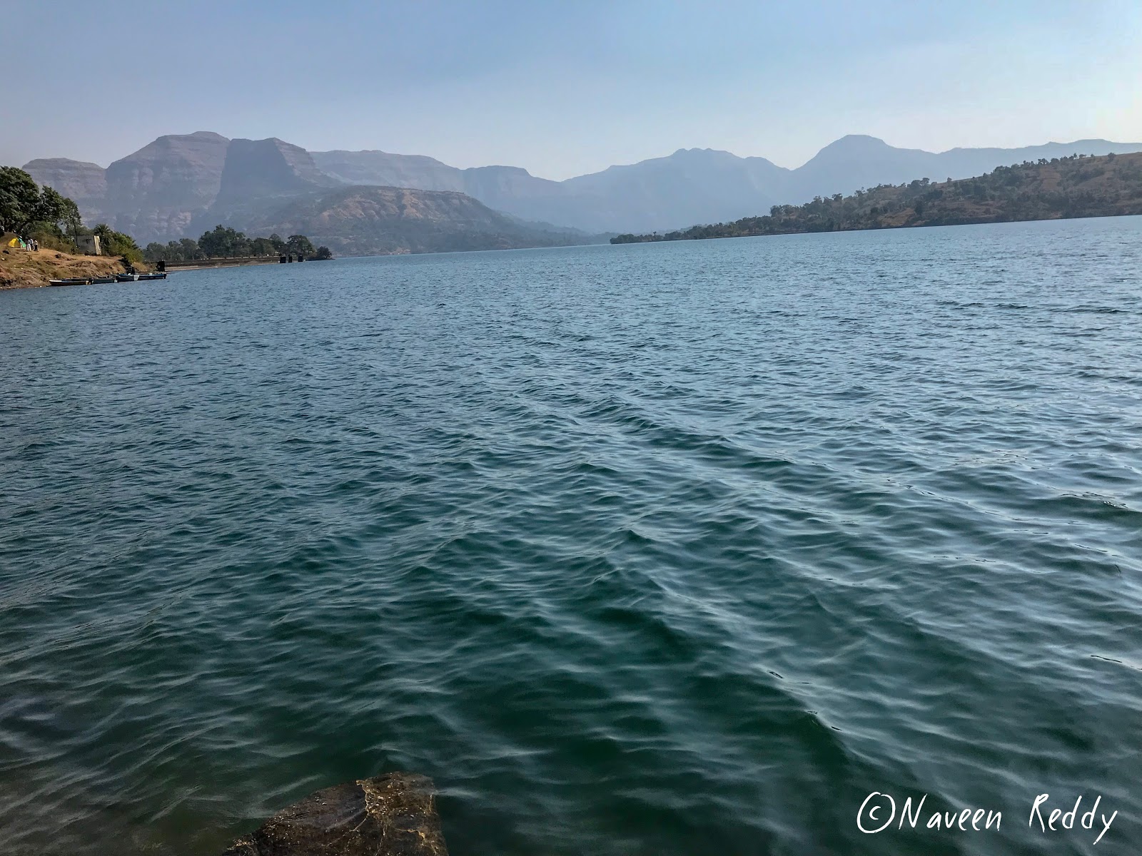
Bhandardhara Dam View!!
Trek to Kalsubai peak was a surreal experience. We reached Kasara by 12:45 AM where Tirth had arranged for a taxi to reach Bari village. It is advisable to pre book a taxi if travelling from Kasara. It took 1+ hour to reach Bari village. Being January we were experienced chilly, but it was quite pleasant. As an alternative spending the night at Bari village, one can reach Bari village early in the morning and start trek as early as possible.
Kalsubai Peak as seen from Bari Village.

We started our journey towards the summit at 3:00 AM after introducing each to others. You will be able to see breathtaking views of Bari village and surrounding area as scale towards the top. Monsoons, however – are the forerunner to splendid greenery all around here. The onset of the monsoon season is in June, when the Sahyadri’ s blooms with all of its vivaciousness and vehemence. Between the months of June and August, Sahyadri hills face some heavy rainfall that leaves the weather of Sahyadri humid, wet and cool. The average annual rainfall in the Sahyadri hills ranges between 3,500 and 8,000 millimeters. The beauty of the seasonal waterfalls of Sahyadri hills is best experienced during the months between July and September. Monsoon is also the season for the adventurous people as this is the season in which adventure activities is in full swing. The natural beauty is there in abundance for you to enjoy all year long. If you are planning a trip in the summertime, then you should dress in light cotton clothing. If you plan to schedule your visit closer to the winter months in Sahyadri's, come along with your woolen apparel.
Mt. Kalsubai 
The weather conditions was perfect for hiking, there was light cool breeze blowing, I never had to exudate while mounting up. I reached my first ladder steps at 4.30 am, so it took me 90 minutes to figure out the way from Bari to the ladder along with the various breaks I took. The first ladder is series of steps with railing on one side, these ladders are usefully placed so as to make the trek more accessible to common people, they are placed where there are rocks and one can overcome this rocks by crossing on the stepladders. There are four ladders on the way with the last two being very steep.
Second Ladder!!
From here on the route is straightforward, just follow those series of ladder till you reach a table top, from there just follow in the direction of the peak which becomes visible and reach the final ladder which will take you to the top of the mountain. Though the trek looks easy but you must have good endurance level, prepare to walk at least for three to four hours from the Bari village. One has to be careful while climbing the ladders, as some of them are placed on vertical sections. The other danger is there are loose soil and gravel all along the trek which could make one slip if not careful. So be cautious, don’t be in hurry, or challenge yourself for something foolish. The good thing about this route is that there are railing provided for the steps and ladder sections.
A view from table top.
The view becomes more and more beautiful as to go up. You will be able to actually walk amongst the clouds as you scale further up during monsoon. One needs to climb 4500 feet from Bari village base through bushes, slippery patches and iron stairs to reach the top. Overall, Kalsubai is not a difficult trek but it does test your endurance and resolve. And that's a trekker wanted to prove, beyond the greed of getting some good pictures. We were the first group started towards the summit. Mt. Kalsubai offers a fantastic view of Sahyadri mountain ranges from the top. It took us four hours to reach the top with breaks in between. But it has been flooded with tourists which makes place lose its charm, Otherwise it would have been a fantastic summit.
Kalsubai range of Hills.

Dawn at Peak.


The view from the top is breathtaking, could see mountains all around you, also one can see the backwaters of Bhandardara dam, the various forts like Ratangad, Harischandragad, Alang, Madangad, Kulang and more. We were carrying food and water for our breakfast, had breakfast at the top. We were at the top for more than hour and decided to descend by 8:45. Now descending can be little tricky. Moving down the ladders will certainly test your fear of height.
Rest time.


Getting down from third ladder-steps.
There are many numbers of monkeys here, they are a very common sight, leaping from boulder to boulder or climbing the trees. They are a restless race with bulky bodies and black faces, though some have a red or a whitish tinge in the color of their faces. It is a very funny spectacle to see their females clutching their little ones close under their bellies and jumping or their kids engaged in a hot quarrel. They never molest the passersby though in some of them familiarity with mankind, However, while hiking on Kalsubai trail, just be careful and don't carry any type of bag in hands they may attack you assuming it as a food.


We decided to descend without wasting time grabbing rocks and jumping.In between we took break to finish rest of the drinks and snacks then continued with rappelling kind of descend. Descending was easy compared to ascending, at certain points; the steep descends risky due slippery surface. It took us around three hours to descend safely and come to the Bari village. The time was around 12’o clock and it was time proceed to Bhandardhara for Sandhan valley expedition with great memories in mind of Everest of Maharashtra’s climb. The best example of how much you can stretch your mind in a given situation. Each and every aspect of great nature met while ascending and descending down the summit, taught us the way of living together in adverse conditions (Quite common in every trek).
Me at last ladder just below the summit.
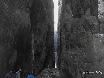
In the subsequent blog post I will contemporary the detailed account of my adventures in Sahyadri’s own Grand Canyon one and only Sandhan Valley.

Thursday 23 November 2017

Ravishing Serendipity At Pushpagiri Forest; Kumara Parvatha Trek

Trekking and making journey as a hobby just happens to you, you never try hard to chase it. I had covered all the major trekking trails near Bangalore in my 4 years stay here. But the Kumar Parvatha trail was long due.
At Summit.
Kumara Parvatha also called a Pushpagiri, is one of exciting trek locations in Karnataka. Popular among trekking fans as KP, the Kumara Parvatha trail is well trodden but equally challenging. Typically takes over night stay on the mountains to finish the trail, if you start trail from Somawarpet side you could able to finish the trail end of the day unlike other side from Kukke. The trek route is fairly in an East - West Orientation across the Western Ghats. In other words you will be trekking across the Western Ghats, scaling the third highest peak in Karnataka.
Sri Shantha Mallikarjuna Temple, Heggademane Village.
The eastern end of the trek is a Beedahalli, a remote village, some 22 km from Somwarpet town in Coorg. The western end is practically the car street of temple town Kukke Subramanya temple. For those of you who haven’t heard about this quiet lesser known place Pushpagiri Wildlife Sanctuary which has Kumara Parvatha and temple town Kukke Subramanya, Subramanya is famous for the Kukke Subramanya temple.

Embraced by the Kumardhara River, this town worships the snake god. Apart from the temples, for the people who are interested in wilderness and drives, this proves to be a perfect place. There are many dirt tracks leading to small villages and mountains near by situated deep inside, but it is advisable to take those routes in winters and early in the summer as trail during monsoon makes more challenging. The place has such a thick tropical forest that if by any chance you lose way, there is no chance that you’ll be able to come out of the jungle on your own.
Just started the trail.
Between these two points Beedahalli and Kukke lies a varying stretches of terrains with, equally varying difficulty to trek. Approximately at the midway point is the Kumara Parvatha peak, hovering over 5,600 feet above sea level.
So here come the first decision you would need to make, if to trek from Subramanya side or from Beedehalli side. And still, if you would want to trek the full trail or trek up to the Kumara Parvatha peak and return back to your starting point, be it Subrahmaniya or Beedehalli.Whatever is the decision, it's about 20km of trek overall.The biggest highlights of Kukke Subrahmaniya end are its better connectivity and the relatively better facilities around the town (hotels, shops, restaurants etc).  And of course the Kukke Subrahmaniya Temple itself.

How does it fare on the Beedehalli side? This tiny village is sparsely connected with Somwarpet by the lone bus service. This is about a 22km journey. You need to get to Somwarpet for any long distance connections, like to to Bangalore (240km, 5hours) or Madikeri (40km, 1½ hours). There are about 6 direct bus services between Somwarpet or Bangalore. And quite a few to Madikeri with Somwarpet.If that lone bus service to/from Beedehalli does not gel well with your itinerary, consider hiring a local jeep service to Somwarpet, a popular means of transport in this part of the state.
Hangover Bridge near APC.
In summery, the Kukke side fares a bit well from the connectivity stand point. What about the trek itself? Which direction is more favorable? From Kukke or Beedehalli? For a couple of reasons the Beedehalli side is a shade batter to set off the trek. To understand this take a look at the topography and the nature of the trek path.The 14km trail from Kukke to Kumara Parvatha peak is all about scaling 1½km (about 1500 m/4930 feet) in elevation. From the Beedehalli you'll reach the Kumara Parvatha peak after 600 meters of elevation over a 7km long trek. That's Beedehalli is already at an elevation of 1100 meters, where as Kukke is about 140 meters.So from a difficulty scale the Beedehalli to Kumara Parvatha peak fares better or less challenging, if you're an avid climber.
Except me.
With all these pros and cons we had chosen Beedahalli APC to start the trek. This side of KP less known to the trekking fraternity of Bangalore which poses an equal amount of challenge along with comforts when compared with Kukke side.This is a trek for all of us who have been wanting to be on top of Kumara Parvatha for a long time. One of the major attractions about path from Beedahalli side is the dense forest cover more or less throughout the peak. The dense cover trail is around 7 kms from the start, last one kilo meter is less covered with forests and has some huge volcanic rock formations one has to climb.
Don't ask what I was thinking of!!

To begin with, this trek was planned one month back. Although I wanted to make this trek happen, it was difficult to get people to confirm and also arrange for a tent and sleeping bags.I spoke to Yathiraj a freelance Well-known travel guide(Organised our Brahmagiri trek) who works closely with KMA and YHAI. We confirmed our interest with Raj and we went to get a sore foot.I was longing to go to this place ever since, so decided to trek the hill Kumara Parvatha as I committed , early in the winter with my colleagues Nagesh, Pramod, Hemanth, Thilak, Guru, Yuvraj, Prakash, Sagar, Sanjay, Sandesh and my cousin Deekshith.
Posing like ..!
Reached Shanta Mallikarjuna temple at Heggademane village after over night journey by 5:30 in the morning. After a break of about 2 hours which included freshen up near the temple, finishing morning daily routines and also having breakfast.This was at 8:00 am, Started off towards the hills. The road became thinned, people density reduced to zero and finally we found a small camp Bedahalli APC. Yathiraj managed to get permission to get into the forest from the forest department, Madikeri range.
Near Second stream.
We left all our extra baggage,tents we carried at APC and started the climbing.Now the actual trekking starts into the thick forest, our plan to come back to the APC to stay in the tents we had for the night and try to visit the beauteous Mookanamane water falls.We had come well stocked as far as food was concerned, Carried almost 70 rotis and Chutney Powder, lot of Curd and Vegetable Salad for munching.We stopped for water at a couple of small streams flowing down across.The tree cover cast a pale green shadow over everything and the recent rains had put that cool, semi wet tropical touch on the trail. Walking along it, it was easy to ignore the leeches pushing for space in my shoes and simply get lost in the wilderness around me.
Leechy Deekshith.
While climbing up the rock face which was pretty easy by the way, since it was mostly dry and my shoes gave me good grip on them, I was wondering how it would be like in the rains.I could see water channels all over them and thought about how cool it would be to climb it in the rains! After that, the gradient continued to be high. Every one starting to feel tired and had to take a couple of breaks in between.The initial part of the trail was very easy and I soon got ahead of the others as I was walking at a pretty brisk pace.  Soon, we came to a pretty steep(about 50 to 60 degree I guess) rock face and from then on the climb was pretty tough.This stretch is more like a rock climbing experience as there is a monolithic stone formation which you have to cross.
Diversion sign board to Peak and Girigadde.

Monkey Skills.
Small rock patch.
Finally, by about 1’o clock we broke out of the tree cover and to the stretch of rock just below the peak. From here you could able to reach the top of KP just in matter of time.The weather atop the peak had absolutely no relation to the conditions below it. It was little hazy and clear continually following, by the time we reach peak we were all very hungry. To add more amusement for sometime Thilak, Pramod, Yuvraj became just like African hunger victims literally attacking me to take away and pulling the vegetables while I am preparing the vegetable salad. Took out the food we had Chapathi and Chutney powder we had, finished it just in matter of time. Once we done with our lunch Photography as usual started off with a bang. All of us clicking pictures, admiring the beauty of Pushpagiri Wildlife Sanctuary.
Just after first rock patch.

Pammi n Hemu.
We were out of the peak and into the ridge adjacent to the peak lush green grass land was visible all around you up to at least 30 kms.The sight was just an elevated feeling of how wonderful nature is. You could see two peaks other from the peak namely Shesha Parvatha and actual Kumara Parvatha hill(We were on Pushpagiri Hill by now).Around 2:30 we started back, the descent was little steep as conquered, unfortunately Sagar suffered with muscular contraction while getting down. No matter what he took his time and got down in company with us which made a very good time throughout. A dog accompanied us on our way down for me and Sanjay all along.
Second rock patch.

Sesha Parvatha.
By 6’o clock everybody was there at APC, we split into random groups while descending down had an opportunity to explore the stunning scenery of Pushpagiri forest. Even though we were tired we maintained our grit and tenacity.It became dark, temperature fallen down to 15c at the time which made bit uneasy. It took about two hours to prepare dinner comprised of Rasam, Rice, Pickle, Papad and Butter milk. It is normal in routine life but being trekked whole day made us tired enough, since everyone hungry it became sumptuous meal for us.

He He...,


Prakash and Yuvi.
When everybody was ready to sleep, Pramod started his relentless chat session with Yuvraj and Hemanth. They were discussing about ranging from least to most happening things in boys life and made sure that nobody got a good sleep. I was snoring all night(Thilak and Deekshith was prey for this whole night)... but I am damn sure that I didn't!! That morning when we woke up the temperature would have been somewhere around 10 degree Celcius or so and we were shivering. Myself and Yathiraj prepared poha for Breakfast meanwhile everyone got freshen up at near by stream flowing down to the valley. Soon finished our Breakfast, with full tummies our day of exploration continued from Beedahalli APC bidding adieu to forest staff.
Early in the morning.
It is around 30 kms from Beedahalli to reach Mookanamane falls. On a brighter day we got to drive around some lonely roads with lovely views.The Mookanamane falls is located 35 km from Taluk headquarters Sakaleshpura, 12 km from Vanagur and hardly 3 km from Attihalli village.By the time we reach Mookanamane falls it was around 11:30. To reach the waterfalls one has to follow the Jeep track by parking the vehicles half a kilometer from the falls. Small vehicles like cars could go further down almost near to falls upstream. A small and wider Nagarahole stream flows down all the way from Bisle Ghat range of hills. The mesmerizing waterfalls located amid the forest makes it almost a private waterfall due to less holidaymakers. The water falls from around 10 to 15 feet height and spread across about 20 mts.

Mookamana Abbey Falls.
It was adventurous walk along the upstream to reach down the falls. The rocks are very slippery and one should be very cautious when they do adventures on the rocks. We managed to reach down the falls with Trees, roots and rocks to our rescue.Few sat on the wet rocks, remaining had nice shower under the huge falls. We thoroughly enjoyed the glory of Mookanamane waterfalls and beauty of nature at its best.I was busy planning and dreaming about my next trek(trip) meanwhile everyone enjoying the movie our way back. Overall the visit to this place is worth and if you are planning to go there, you will get to see some of the virgin beauty. Pushpagiri and Bisle reserve forest are the perfect choice for a attraction that lets you experience the mesmerizing quality of being pleasant.

Bidding Adieu to APC.


Getting lost in Sandhan Valley; Maharashtra's Very Own Grand Canyon.

Continuous from Kalsubai trek .   Exploring the Sandhan Valley (The Grand Canyon of Maharashtra) along with visit to Bhandardara dam ...

StatCounter